Maptech Waterproof Chart WPC093, Winyah Bay to Charleston, SC, 1st Edition, 2001

RM-C093

New product

*** Discontinued circa Apr. 2019, no longer available

More details

Shipping Rates

 
More info

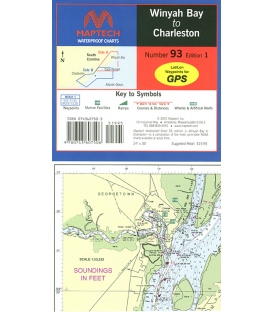
Winyah Bay to Charleston SC, Ed. 1, Coverage to 20 miles offshore, Winyah Bay to Georgetown, and Charleston Harbor. Contains pre-plotted GPS waypoints and courses, marine facilities, artificial reefs and wrecks, state parks, and local gamefish. Approximate scale 1: 106,666 with insets.

Reviews

30 other products in the same category:

Customers who bought this product also bought:

QR code

Top
Accept

Maryland Nautical uses cookies to enhance your e-commerce experience.  To view more information about our cookie use, click here to view our Privacy Policy