- Home
- >
- Nautical Charts
- >
- Waterproof Charts
- >
- Richardson's Maptech
- >
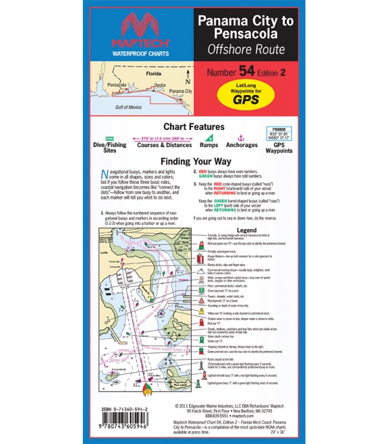
- WPC054 Panama City to Pensacola - Offshore Route, 2nd Ed., 2011, Maptech Waterproof Chart
Categories
- CLEARANCE
- New Editions
- Nautical Charts
- Nautical Books
- E-Readers & E-Books
- Occupational Safety & Health Administration (OSHA)
- Destinations
- Code of Federal Regulations (CFR)
- USCG Exam Study Materials
- International Maritime Org. (IMO)
- Sealite Aids to Marine Navigation
- Flags
- Digital Charts
- Nautical Software
- Marine Supplies
- Navigation Equipment
- Intracoastal Waterway
- Ocean Cruising
- Great Circle Route
- Gift Shop


Sign up for our Newsletter
RM-C054
New product
Unique Flip-Fold Charts for Use in Any Weather.
Made from a durable, long-lasting, synthetic paper.
24" x 36"
Scale 1:106,666 with insets.
Panama City to Pensacola - Offshore Route, New 2nd Edition, Includes insets of inlets and major destinations. Features waypoints for major aids to navigation, pre-plotted courses and distances, public boat launch locations, fish and dive sites and tables.
Convenience
Our “flip-fold” charts are easy to manage. Spread the chart out to its full width, or keep it folded and flip to your favorite area.
Quality
Maptech’s charts are printed on high-quality, waterproof, synthetic paper. Chart images are crisp and easy to read.
Value
The extensive coverage in just one Waterproof Chart will save money compared to the cost of multiple charts to cover the same area.
Waterproof Chart Features:
• User-Friendly, Flip-Fold Format • GPS Waypoints • Key Symbols and “Finding Your Way” Tips • Extensive, Highly Detailed Coverage
Reviews
30 other products in the same category:
Customers who bought this product also bought:
- About Us
- Our Services
- Ordering & Shipping
- Resource Links
- Blog
- CLEARANCE
- New Editions
- Nautical Charts
- Nautical Books
- E-Readers & E-Books
- Occupational Safety & Health Administration (OSHA)
- Destinations
- Code of Federal Regulations (CFR)
- USCG Exam Study Materials
- International Maritime Org. (IMO)
- Sealite Aids to Marine Navigation
- Flags
- Digital Charts
- Nautical Software
- Marine Supplies
- Navigation Equipment
- Intracoastal Waterway
- Ocean Cruising
- Great Circle Route
- Gift Shop
Maryland Nautical uses cookies to enhance your e-commerce experience. To view more information about our cookie use, click here to view our Privacy Policy.

