Sign up for our Newsletter


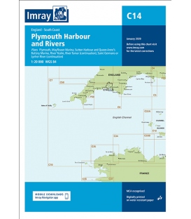
Imray Chart C14 Plymouth Harbour and Rivers
Scale: 20000
Paper Size: 36.0" x 48.0"
Actual Chart Size: 28.9" x 42.8"
Edition Date: 2022-01-01
Online Chart Viewer
More info
Imray Chart C14 Plymouth Harbour and Rivers
Scale: 1:20 000 WGS 84
Plans included:
Plymouth (1:12 500)
Mayflower Marina (1:4500)
Sutton Harbour and Queen Anne’s Battery Marina (1:4500)
River Yealm (1:12 500)
Continuation of River Tamar (1:20 000)
Continuation of Saint Germans or Lynher River (1:20 000)
This edition includes the latest official data combined with additional information sourced from Imray's network to make it ideal for small craft. It includes the latest official bathymetric surveys. There has been general updating throughout.