Sign up for our Newsletter
")
")
")
")
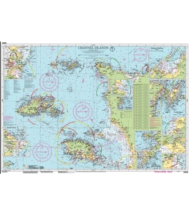
Imray Chart C33A Channel Islands (North)
Scale: 120,000
Paper Size: 36.0" x 46.0"
Actual Chart Size: 29.5" x 42.2"]
Edition Date: 2022-10-01
Online Chart Viewer
More info
Imray Chart C33A Channel Islands (North)
Scale: 1:120,000 WGS 84
Plans included:
Alderney Harbour (1:9000)
Beaucette Marina (1:15 000)
St Sampson Hbr (1:20 000)
St Peter Port (1:10 000)
Creux Harbour Approaches (1:25 000)
Gorey (1:20 000)
Omonville (1:7000)
Herm Harbour & Rosière Anchorage (1:30 000)
Diélette (1:15 000)
Carteret (1:22 500)
Bays of Sark (1:25 000)
Little Russel (1:50 000)
This edition includes the latest official UKHO and SHOM data, combined with additional information sourced from Imray''s network to make it ideal for small craft. The chart has been fully revised throughout including the latest bathymetric survey data.