Sign up for our Newsletter


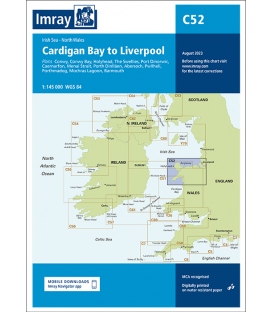
Imray Chart C52 Cardigan Bay to Liverpool
- Stock code: ICC52-3
- Author: Imray
- Publisher: Imray
- Publication details: Sheet size 787 x 1118mm. Waterproof. Folded in plastic wallet or flat.
- Edition date: 2023
- Printed and corrected to: August 2023
- ISBN: 9781786794987
Paper Size: 36.0" x 45.0"
Actual Chart Size: 29.7" x 41.9"
Online Chart Viewer
Imray Chart C52 Cardigan Bay to Liverpool
Scale: 1:145,000 WGS84
Plans included:
Conwy (1:30 000)
Conwy Bay (1:60 000)
Holyhead (1:25 000)
The Swellies (1:15 000)
Port Dinorwic (1:15 000)
Caernarfon (1:15 000)
Menai Strait (1:60 000)
Porth Dinlläen (1:17 500)
Abersoch (1:15 000)
Pwllheli (1:15 000)
Porthmadog (1:10 000)
Mochras Lagoon (1:15 000)
Barmouth (1:30 000)
This edition includes the latest official UKHO data, combined with additional information sourced from Imray''s network to make it ideal for small craft. The chart has been fully revised throughout. The harbour plan of Holyhead has been reschemed to a scale of 1:27 500.
The chart includes charting and tidal data for passage, approach, and mooring, and is designed to be used alongside Cruising Anglesey and adjoining waters by Ralph Morris and the Irish Sea Pilot by David Rainsbury, both published by Imray.