Sign up for our Newsletter


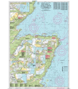
Imray Chart C23 Fife Ness to Moray Firth
- Stock code: ICC23-3
- Author: Imray
- Publisher: Imray
- Publication details: Sheet size 787 x 1118mm. Waterproof. Folded in plastic wallet or flat.
- Edition date: 2023
- Printed and corrected to: July 2023
- ISBN: 9781786794819
Paper Size: 36.0" x 46.0"
Actual Chart Size: 29.1" x 42.8"
Online Chart Viewer
Imray Chart C23 Fife Ness to Duncansby Head
Scale: 1:250,000 WGS 84
Plans included:
Wick Bay (1:10 000)
Helmsdale (1:10 000)
Inverness Firth (1:75 000)
Nairn (1:7500)
Burghead (1:8000)
Hopeman (1:7500)
Lossiemouth (1:7500)
Buckie (1:15 000)
Banff & Macduff (1:25 000)
Fraserburgh (1:7500)
Peterhead (1:17 500)
Aberdeen (1:20 000)
Stonehaven (1:17 500)
Montrose (1:12 500)
Arbroath (1:15 000)
Inverness (1:25 000)
This edition includes the latest official UKHO data, combined with additional information sourced from Imray''s network to make it ideal for small craft. The chart has been fully revised throughout and includes the latest windfarm developments.
The chart title has been changed on this edition to ‘Fife Ness to Duncansby Head’ to give clearer definition of the geographic area covered.