Sign up for our Newsletter


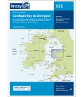
Imray Chart C51 Cardigan Bay
Scale: 145000
Paper Size: 36.0" x 48.0"
Actual Chart Size: 31.0" x 44.0"
Edition Date: 2015-09-01
Online Chart Viewer
More info
Imray Chart C51 Cardigan Bay
Milford Haven to Tremadog Bay
Scale: 1:145 000 WGS 84
Plans included:
Pwllheli (1:12 500)
Aberdovey (1:25 000)
Aberystwyth (1:15 000)
Aberaeron (1:20 000)
New Quay (1:20 000)
Aberporth (1:30 000)
Cardigan (1:40 000)
Newport Bay (1:35 000)
Fishguard (1:18 000)
Entrance to Milford Haven (1:30 000)
On this edition the chart has been fully updated throughout. Revised depths are shown at Aberdovey, Fishguard, the waters south of St David’s Head and in the entrance to Milford Haven.