Sign up for our Newsletter


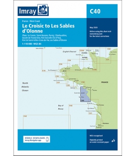
Imray Chart C40 Le Croisic to Les Sables d’Olonne
Scale: 110000
Paper Size: 36.0" x 48.0"
Actual Chart Size: 31.0" x 44.0"
Edition Date: 2020-05-01
Online Chart Viewer
Imray Chart C40 Le Croisic to Les Sables d’Olonne
Scale: 1:110,000 WGS 84
Plans included:
Le Croisic (1:15 000)
Saint-Nazaire (1:25 000)
Pornic (1:12 500)
L’Herbaudière (1:12 500)
Goulet de Fromentine (1:30 000)
Port-Joinville (Île d’Yeu) (1:10 500)
Port de Saint-Gilles-Croix-de-Vie (1:15 000)
Les Sables d’Olonne (1:20 000)
On this edition the chart specification has been improved to show coloured light flashes. The latest depth surveys have been included where available and the firing practice area has been updated. Extra tidal stream data is included for Baie de Bourgneuf. The marina layout at L’Herbaudière has been revised to show its new configuration. There has been general updating throughout.