- Home
- >
- Nautical Charts
- >
- Imray-Iolaire Nautical Charts
- >
- North Atlantic Ocean Region
- >
- Imray Chart C28 Harwich to Wells-next-the-Sea
Categories
- CLEARANCE
- New Editions
- Nautical Charts
- Nautical Books
- E-Readers & E-Books
- Occupational Safety & Health Administration (OSHA)
- Destinations
- Code of Federal Regulations (CFR)
- USCG Exam Study Materials
- International Maritime Org. (IMO)
- Sealite Aids to Marine Navigation
- Flags
- Digital Charts
- Nautical Software
- Marine Supplies
- Navigation Equipment
- Intracoastal Waterway
- Ocean Cruising
- Great Circle Route
- Gift Shop


Sign up for our Newsletter
II-C028
New product
- Stock code ICC28-5
- Author Imray
- Publisher Imray
- ISBN 9781786794208
- Edition date 2022
- Publication details Sheet size 787 x 1118mm. Waterproof. Folded in plastic wallet or flat.
Paper Size: 36.0" x 46.0"
Actual Chart Size: 29.1" x 42.7"
Online Chart Viewer
More info
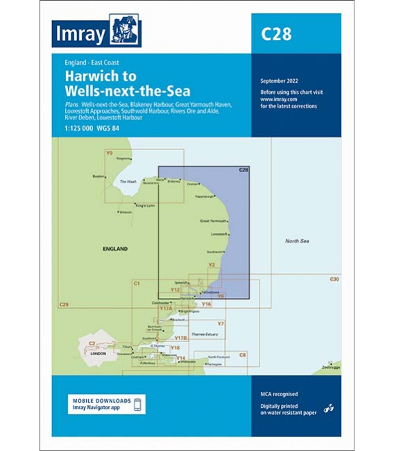
Imray Chart C28 Harwich to Wells-next-the-Sea
Scale: 1:125 000 WGS 84
Plans included:
Wells-next-the-Sea (1:30 000)
Blakeney Harbour (1:28 000)
Great Yarmouth Haven (1:10 000)
Lowestoft Approaches (1:42 500)
Southwold Harbour (1:12 500)
Rivers Ore and Alde (1:42 500)
River Deben (1:45 000)
Lowestoft Harbour (1:12 000)
This edition includes the latest official UKHO data, combined with additional information sourced from Imray's network to make it ideal for small craft. The chart has been fully revised throughout.
Reviews
30 other products in the same category:
- About Us
- Our Services
- Ordering & Shipping
- Resource Links
- Blog
- CLEARANCE
- New Editions
- Nautical Charts
- Nautical Books
- E-Readers & E-Books
- Occupational Safety & Health Administration (OSHA)
- Destinations
- Code of Federal Regulations (CFR)
- USCG Exam Study Materials
- International Maritime Org. (IMO)
- Sealite Aids to Marine Navigation
- Flags
- Digital Charts
- Nautical Software
- Marine Supplies
- Navigation Equipment
- Intracoastal Waterway
- Ocean Cruising
- Great Circle Route
- Gift Shop

