Sign up for our Newsletter


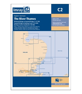
Imray Chart C2 The River Thames
Scale: Various
Paper Size: 36.0" x 48.0"
Actual Chart Size: 31.0" x 44.0"
Edition Date: 2020-06-01
Online Chart Viewer
Imray Chart C2 The River Thames
Scale: Various scales WGS 84
Teddington to Southend in three panels
Richmond Bridge to Vauxhall Bridge (1:13 700)
Vauxhall Bridge to Barking Creek (1:16 500)
Barking Creek to Southend (1:40 400)
Plans included:
Gallions Point Marina (1:9000)
South Dock Marina (1:5000)
Limehouse Basin Marina (1:5500)
St Katherine Haven (1:5250)
Chelsea Harbour Marina (1:2750)
Brentford Dock Marina (1:3000)
On this edition depths from the latest surveys have been applied throughout. The chart also now shows the London Gateway Container Port, as well as the revised buoyage in its approaches. Various developments to harbours and jetties are also shown.