No products
Prices are tax included
Check out
Sign up for our Newsletter
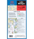
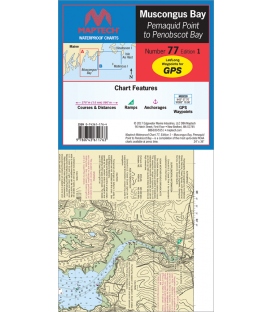
Tweet Share Google+ Pinterest
Reference: RM-C077
Condition: New product
Featuring waypoints for major buoys, courses and distances, ramp and anchorage locations.24" x 36", scale 1:48, 200 with insets.
ISBN 9780743611763
More details
$26.95
- +
Add to cart
The minimum purchase order quantity for the product is 1
Shipping Rates
Maptech Waterproof Chart WPC077, Muscongus Bay (Pemaquid Pt. to Penobscot Bay (1st, 2017)
Be the first to write your review !
Maptech - Little Egg Harbor, NJ...
Maptech - Cape Ann to Cape...
Maptech - Mt. Desert Island to...
Maptech - Annapolis to Cambridge...
Maptech - Fire Island, NY to...
Maptech - Little Egg Inlet, NJ...
Maptech - Delaware Bay and the C...
Maptech - Champlain Canal...
Maptech - Lake Champlain...
Maptech - Hudson Canyon to...
Maptech - Tarpon Springs to...
Maptech - Horseshoe Beach to...
Maptech - Carrabelle to Panama...
WPC054 Panama City to Pensacola...
Maptech - Mobile Bay to...
Maptech - Mobile Entrance to...
Maptech - New Orleans and Lake...
Maptech - Casco Bay Waterproof...
Maptech Waterproof Chart WPC074,...
Maptech Waterproof Chart WPC075,...
Maptech Waterproof Chart WPC076,...
Maptech - Annapolis Waterproof...
Merrimack River and Plum Island...
Maptech Waterproof Chart WPC084,...
Martha's Vineyard to...
Maptech - Fishers Island to...
Maptech Waterproof Chart WPC087,...
Maptech Waterproof Chart WPC088,...
Albemarle & Pamlico Sounds...
Maptech Waterproof Chart WPC090,...
Maptech Waterproof Chart WPC077,...
British Admiralty Nautical Chart 2...
British Admiralty Nautical Chart 5529...
British Admiralty Nautical Chart 5504...
Maryland Nautical uses cookies to enhance your e-commerce experience. To view more information about our cookie use, click here to view our Privacy Policy.