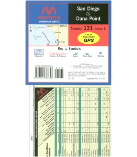
San Diego to Dana Point, Ed. 1, Dana Point to the border and a detailed chart of San Diego. Includes Dana Point, Oceanside, and Mission Bay, pre-plotted GPS waypoints and courses, marinas, and wrecks and obstructions. 24Ó x 36Ó Approximate scales 1:16,000 and 1:133,333 with insets
Maryland Nautical uses cookies to enhance your e-commerce experience. To view more information about our cookie use, click here to view our Privacy Policy.