Sign up for our Newsletter


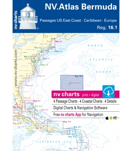
Region 16.1, Bermuda Islands, Passages US East Coast, Caribbean & Europe 2016/17
ISBN: 9783932414756
- • Passage Charts
- • Coastal Charts
- • Details
- • GPS Charted Waypoints & Approaches
- • This Chart Region is based on BA data with a new layout, clear cartography and international chart standards
- • Standardized chart scales - passage charts 1:340,000 - 1:7,500,000 coastal charts 1:90,000 and detail charts 1:20,000 or less
Region 16.1, Bermuda Islands: Passage US East Coast, Caribbean & Europe 2016/17 Edition
Ocean Charts
C1 North Atlantic Ocean with General Surface Current Circulation 1: 7,500,000
C2 Caribbean to Bermuda Islands 1: 3,000,000
C3 US East Coast · Bermuda Islands · Caribbean 1: 6,000,000
C4 Newport to Bermuda 1: 3,000,000
Coastal Charts
C5 Bermuda Islands 1: 90,000
C6 St. George´s Island 1: 20,000
C7 North Channel to Hamilton 1: 30,000
C8 Great Sound 1: 20,000
Details
C9A Castle Harbour 1: 20,000
C9B St. George´s Harbour 1: 12,000
C10A Hamilton Harbour 1: 12,000
C10B Ireland Island 1: 10,000
| Practical to use and accurate in the information and data published: This is the basic concept with which we have developed the nv-charts and the Harbor & Anchorage Pilot Books. | ||||||||||||||||||||||||||||||||
|
|
|||||||||||||||||||||||||||||||
The nv charts are characterized by fine contours and easy to distinguish color graduations of the depth lines. The importance of good graphical representation of the topography when sailing is essential. Well marked rivers, towns and street plans all help to give a clear overall view of the shore side facilities of the islands. In waters soundings and heights are given in meters. Large scale approaches and land contour markings simplify the entrance into anchorages.