Sign up for our Newsletter


More info
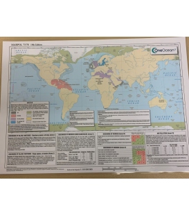
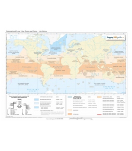
International Load Line Zones and Areas Map, 16th Edition 2019
This map summarises data from the International Convention on Load Lines 1966 and Protocol of 1988, as amended in 2003. With effect from January 2014 the Southern Winter Seasonal Zone boundary has changed.
The International Load Line Zones and Areas map outlines Summer, Winter and Tropical Zones, Seasonal Areas as well as their Fresh Water equivalents. Also included are the recent boundary changes which took effect from January 2014.
Also listed are the co-ordinates of the outer limits. Applicable dates are shown below the map, together with a schematic of standard load line markings and abbreviations.