Sign up for our Newsletter


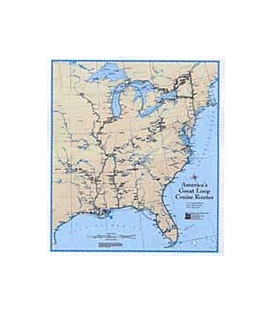
America's Great Loop Cruise Routes Map (23x27") (2001)
Many boaters dream of cruising America's Great Loop (A.K.A. Great Circle) and plan the trip for years in advance. This poster-sized map shows detail which is helpful when planning the cruise. Features include accurate placement of navigable rivers, locks and dams and major cities and ports of Eastern North America. The various routes of the cruise are lightly outlined in colors to represent the ideal time to be on each segment - green in spring on the East Coast, orange for summer in the Great Lakes and beige in the fall on the Inland Rivers and Florida's West Coast. The map is produced in full color on 80# stock and matte-laminated. It is a vital tool to use as a reference with the book, "Honey, Let's Get a Boat…": A Cruising Adventure of America's Great Loop by Ron & Eva Stob. A dry erase marker allows you to write on the map important dates, friends who will visit the boat and a time schedule for completing the Loop. Members often leave a copy behind for friends and family so they can follow their loved ones on their year-long voyage. The map can be framed or rolled and is excellent for planning the Great Loop trip.