- Home
- >
- Nautical Charts
- >
- Imray-Iolaire Nautical Charts
- >
- Mediterranean Region
- >
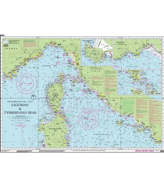
- Imray Chart M40: Ligurian and Tyrrhenian Seas
Categories
- CLEARANCE
- New Editions
- Nautical Charts
- Nautical Books
- E-Readers & E-Books
- Occupational Safety & Health Administration (OSHA)
- Destinations
- Code of Federal Regulations (CFR)
- USCG Exam Study Materials
- International Maritime Org. (IMO)
- Sealite Aids to Marine Navigation
- Flags
- Digital Charts
- Nautical Software
- Marine Supplies
- Navigation Equipment
- Intracoastal Waterway
- Ocean Cruising
- Great Circle Route
- Gift Shop


Sign up for our Newsletter
II-M040
New product
Online Chart Viewer
Stock code: ICM40-2
Author: Imray
Publisher: Imray
ISBN: 9781846236167
Edition:
Edition date: 2014
Last printed: June 2014
Publication details: Sheet size 640 x 900mm. Waterproof. Folded in plastic wallet or flat.
M40 Ligurian and Tyrrhenian Seas
Scale: 1:950,000 WGS 84
Imray
Plans included:
Monte Argentario (1:100 000)
Bonifacio Strait (1:225 000)
Golfo di Salerno (1:100 000)
For this 2014 edition the chart has been fully updated throughout using revised depths where applicable. The full list of recently deployed AIS transmitters are shown across the chart, as is the new marina in Rada di Salerno.
Reviews
30 other products in the same category:
Customers who bought this product also bought:
- About Us
- Our Services
- Ordering & Shipping
- Resource Links
- Blog
- CLEARANCE
- New Editions
- Nautical Charts
- Nautical Books
- E-Readers & E-Books
- Occupational Safety & Health Administration (OSHA)
- Destinations
- Code of Federal Regulations (CFR)
- USCG Exam Study Materials
- International Maritime Org. (IMO)
- Sealite Aids to Marine Navigation
- Flags
- Digital Charts
- Nautical Software
- Marine Supplies
- Navigation Equipment
- Intracoastal Waterway
- Ocean Cruising
- Great Circle Route
- Gift Shop
Maryland Nautical uses cookies to enhance your e-commerce experience. To view more information about our cookie use, click here to view our Privacy Policy.


