Sign up for our Newsletter


More info
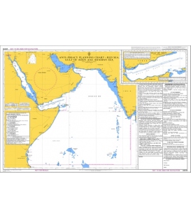
British Admiralty Nautical Chart Q6112 Maritime Security Chart, Karachi to Quanzhou
One of a series of new Maritime Security Charts. These charts contain security related information for the area of that chart, including details of reporting schemes and regional contacts, as well as general security advice. It is to be used in conjunction with standard nautical charts and publications.
Main Chart Details
- Chart Title: Maritime Security Chart, Karachi to Hong Kong
- Publication Date: 02/05/2013
- Latest Edition date: 11/2024
- Chart Size: 843 x 650 (mm)
Chart Panel Details
- Panel Name Maritime Security Chart Karachi to Quanzhou
- Natural Scale 10,000,000
- North Limit 25 00'.00N
- East Limit 118 00'.00E
- South Limit 15 07'.50S
- West Limit 65 00'.00E
Co-ordinates given are usually those of the four extremities of the chart. In many cases not all the area within will be fully charted*.Customers should check that the chart meets their requirements by viewing the chart image (where available).Mariners should always use the largest scale navigational chart available.
*Reasons may include
- Continuation of coverage of a small part outside the main area of chart coverage e.g a river.
- Inset plans and the chart title block and notes also take up space, therefore geographical information cannot be shown in this area.
- A need to refer to larger scale of chart, such waters are often "blued out" to avoid excessive maintenance work applying numerous NM corrections to an area of the small scale chart where the navigator will be using a larger scale chart.
- Coverage is better served from a different chart because of typical routeings.