- Home
- >
- Nautical Books
- >
- Cruising Guides
- >
- Imray, Laurie Norie & Wilson
- >
- Imray Mediterranean Almanac 2023-24
Categories
- CLEARANCE
- New Editions
- Nautical Charts
- Nautical Books
- E-Readers & E-Books
- Occupational Safety & Health Administration (OSHA)
- Destinations
- Code of Federal Regulations (CFR)
- USCG Exam Study Materials
- International Maritime Org. (IMO)
- Sealite Aids to Marine Navigation
- Flags
- Digital Charts
- Nautical Software
- Marine Supplies
- Navigation Equipment
- Intracoastal Waterway
- Ocean Cruising
- Great Circle Route
- Gift Shop


Sign up for our Newsletter
IIMA23/24
New product
- Stock code: IB0228-4
- Author: Edited by Rod and Lucinda Heikell
- Publisher: Imray
- Publication details: Edited by Rod and Lucinda Heikell
- Edition date: 2023/2024
- ISBN: 9781786794420
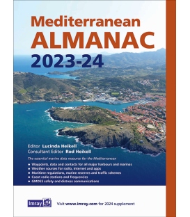
Imray Mediterranean Almanac 2023-24
The essential marine data resource for yachts sailing the Mediterranean, the Imray Mediterranean Almanac is published biennially with updates available in a downloadable supplement at the end of the first year.
It includes:
Data, waypoints and contacts for all major harbours and marinas throughout the Mediterranean Sea plus Atlantic Islands.
Weather sources for radio, internet and apps
Information on lights and buoys
Maritime regulations, marine reserves and traffic schemes
Coast radio stations and frequencies
GMDSS safety and distress communications
Harbour plans throughout, with the familiar Imray cartography which adds clarity to their use. There are the usual detailed revisions throughout this edition, plus many new harbour plans.
Reviews
30 other products in the same category:
- About Us
- Our Services
- Ordering & Shipping
- Resource Links
- Blog
- CLEARANCE
- New Editions
- Nautical Charts
- Nautical Books
- E-Readers & E-Books
- Occupational Safety & Health Administration (OSHA)
- Destinations
- Code of Federal Regulations (CFR)
- USCG Exam Study Materials
- International Maritime Org. (IMO)
- Sealite Aids to Marine Navigation
- Flags
- Digital Charts
- Nautical Software
- Marine Supplies
- Navigation Equipment
- Intracoastal Waterway
- Ocean Cruising
- Great Circle Route
- Gift Shop


