Sign up for our Newsletter


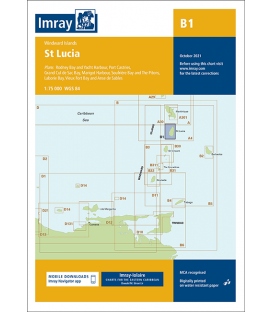
Imray Chart B1 St Lucia

- Stock code ICB1-3
- Author Imray
- Publisher Imray
- ISBN 9781786793119
- Edition date 2021
Paper Size: 36.0" x 38.0"
Actual Chart Size: 23.5" x 34.8"
Online Chart Viewer
Imray Chart B1 St Lucia
Scale: 1:75,000 WGS 84
Plans included:
Rodney Bay and Yacht Harbour (1:25,000)
Port Castries (1:12,500)
Grand Cul de Sac Bay (1:15,000)
Marigot Harbour (1:7500)
Soufrière Bay and The Pitons (1:40,000)
Laborie Bay (1:20,000)
Vieux Fort Bay and Anse de Sables (1:20,000)
Imray-Iolaire charts for Caribbean are widely acknowledged as the best available for the cruising sailor. They combine the latest official survey data with first-hand information gathered over 60 years of research by Don Street Jr and his wide network of contributors. Like all Imray charts, they are printed on water resistant Pretex paper for durability, and they include many anchorages, facilities and inlets not included on official charts.
This edition includes the latest official data combined with additional information sourced from Imray's network to make it ideal for small craft. It includes the latest official bathymetric surveys. There has been general updating throughout.