Sign up for our Newsletter


More info
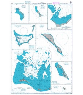
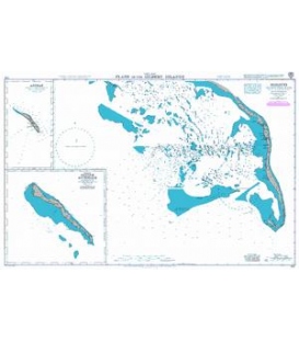
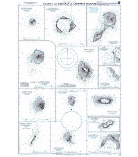
British Admiralty Nautical Chart 910 Plans in the Marianas or Ladrones Islands
is corrected up to date. Admiralty standard nautical charts comply with Safety of Life at Sea (SOLAS) regulations and are ideal for professional, commercial and recreational use. Charts within the series consist of a range of scales, useful for passage planning, ocean crossings, coastal navigation and entering port. Mariners should always use the largest scale nautical chart appropriate to their needs. In particularly busy seaways such as the English Channel, Gulf of Suez and the Malacca and Singapore Straits, the standard nautical charts are supplemented by mariners routeing guides which provide advice on route planning in these complex areas.
Chart 910
Main Chart Details
- Chart Title: Plans in the Marianas or Ladrones Islands
- Publication Date: 29/04/1932
- Latest Edition date: 24/12/1953
- Chart Size: 645 x 950 (mm)
Chart Panel Details
- Panel Name Farallon de Pajaros
- Natural Scale 35000
- North Limit 20 34'.19N
- East Limit 144 55'.35E
- South Limit 20 30'.08N
- West Limit 144 52'.24E
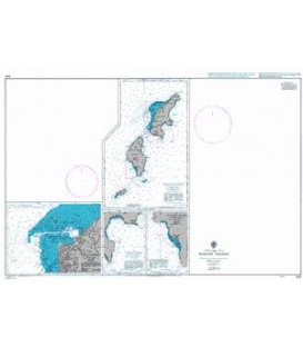
- Panel Name Maug Islands
- Natural Scale 25000
- North Limit 20 03'.08N
- East Limit 145 15'.35E
- South Limit 19 59'.63N
- West Limit 145 11'.61E
- Panel Name Asuncion Island
- Natural Scale 35000
- North Limit 19 41'.97N
- East Limit 145 26'.43E
- South Limit 19 36'.30N
- West Limit 145 21'.92E
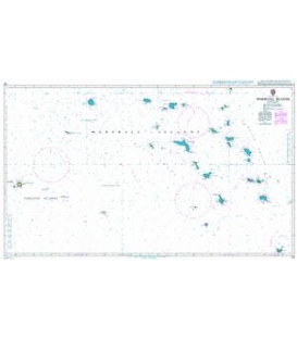
- Panel Name Pagan Island
- Natural Scale 72000
- North Limit 18 11'.92N
- East Limit 145 50'.06E
- South Limit 18 01'.93N
- West Limit 145 41'.55E
- Panel Name Apaan Bay
- Area Name Pagan Island
- Natural Scale 25475
- North Limit 18 08'.30N
- East Limit 145 46'.44E
- South Limit 18 06'.75N
- West Limit 145 44'.49E
- Panel Name Agrihan Island
- Natural Scale 75000
- North Limit 18 52'.19N
- East Limit 145 43'.52E
- South Limit 18 41'.56N
- West Limit 145 32'.28E
- Panel Name Agrihan Anchorage
- Area Name Agrihan Island
- Natural Scale 35000
- North Limit 18 45'.15N
- East Limit 145 40'.00E
- South Limit 18 42'.55N
- West Limit 145 37'.34E
- Panel Name Alamagan Island
- Natural Scale 45000
- North Limit 17 38'.45N
- East Limit 145 52'.81E
- South Limit 17 33'.58N
- West Limit 145 47'.07E
- Panel Name Guguan Island
- Natural Scale 42000
- North Limit 17 20'.52N
- East Limit 145 53'.11E
- South Limit 17 15'.99N
- West Limit 145 48'.57E
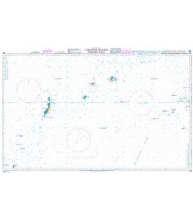
- Panel Name Anatahan Island
- Natural Scale 75000
- North Limit 16 24'.37N
- East Limit 145 44'.60E
- South Limit 16 17'.55N
- West Limit 145 35'.94E
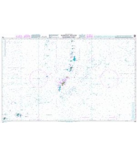
- Panel Name Farallon de Medinilla
- Natural Scale 45000
- North Limit 16 03'.82N
- East Limit 146 07'.13E
- South Limit 15 58'.96N
- West Limit 146 02'.32E
- Panel Name Sarigan Island
- Natural Scale 45000
- North Limit 16 44'.97N
- East Limit 145 49'.99E
- South Limit 16 40'.09N
- West Limit 145 44'.26E
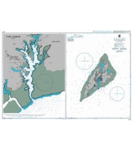
- Panel Name Rota Island
- Natural Scale 200000
- North Limit 14 14'.10N
- East Limit 145 22'.10E
- South Limit 14 04'.40N
- West Limit 144 59'.85E
- Panel Name Rota Harbour
- Area Name Rota Island
- Natural Scale 49000
- North Limit 14 09'.14N
- East Limit 145 10'.95E
- South Limit 14 05'.86N
- West Limit 145 05'.35E