Sign up for our Newsletter


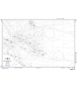
British Admiralty Gnomonic Chart 5098A South Pacific and Southern Oceans


*** Canceled, replaced by BA5098 in NM 35/18 (however, Wellington is a much smaller scale)
More info
British Admiralty Gnomonic Chart 5098A South Pacific and Southern Oceans - showing curves for obtaining true bearings of Wellington
These Charts are used in passage planning to plot great circle routes as a straight line. They are useful for devising composite rhumb line courses. Fifteen charts cover the world at scales of 1:13,500,000 and 1:26,500,000
Chart 5098A
Main Chart Details
- Chart Title: South Pacific and Southern Oceans - showing curves for obtaining true bearings of Wellington
- Publication Date: 01/07/1939
- Latest Edition date: 01/07/1939