Sign up for our Newsletter


Rose Point Coastal Explorer Version 4.0
***Existing Users: Click Here to upgrade to the new Coastal Explorer from either Coastal Explorer 2009 or Coastal Explorer 2011 for just $99
Rose Point Coastal Explorer Version 4.0
Coastal Explorer™ is a sophisticated and full-featured, yet very easy to use navigation software package designed specifically for the pleasure boater.
With support for more charts and chart formats than any other recreational navigation system, route planning features with multi-level undo capability, integrated gazetteer and guide books, virtual instrument display, and obstacle alerts, Coastal Explorer will help you make your next cruise safer and more enjoyable.
Explore |
||
|
The gazetteer includes millions of places in the US, Canada, and Mexico and more countries are available. You can find any of these places on the chart by simply entering a name into the Search Box on the toolbar! Guide Book information is tightly integrated into Coastal Explorer's charts. Sailing directions from the US Coast Pilot® and NGA Enroute for Canada and Mexico are included. Many other guide book add-ons, including the Atlantic Cruising Club's Guides to Marinas and ActiveCaptain, are also available. Coastal Explorer's Guide Book also includes photos from all over the world via Panoramio. |
 |
|
Plan |
||
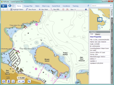 |
Coastal Explorer makes it easy to plan your next cruising adventure with features like multi-level undo, powerful route manipulation tools, and route obstacle detection. Coastal Explorer uses documents instead of a hidden database to keep track of all of your routes, waypoints, boundary areas, and other marks so you can organize them however you want. You can even share them with your friends using e-mail or a USB Flash Drive! |
|
Prepare |
||
|
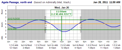
Coastal Explorer can predict tide levels and tidal currents at all official US stations and many Canadian stations. Tide predictions are presented in easy to read graphs along with daily high, low, and slack water times. Weather forecasts are presented in both text and graphical formats and are easily downloaded when you have Internet access. Current weather conditions are also displayed when available. |
 |
|
Navigate |
||
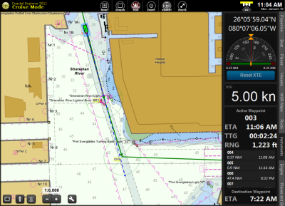 |
Navigation is made easier with Coastal Explorer's full-screen Cruise Mode which replaces the standard Windows menus and toolbars with big buttons that are much easier to use while underway. Split the screen into two, three, or four charts with a single key or button press. There's no need to resize or rearrange windows; Coastal Explorer takes care of it for you! Orient the chart with North Up, Heading Up, or Course Up and let Coastal Explorer automatically scroll the chart to keep your boat centered or near the edge so you can see more of what's ahead. Voice Alerts are used to warn you of waypoint arrivals, depths out of range, and even charted obstacles along your path! Virtual Instrument panels show you information from your electronics in large, easy to see displays. Coastal Explorer includes an analog compass with waypoint arrow, analog wind, cross track error, and rudder angle displays, depth and temperature graphs, and many digital display options. |
|
| Interface Options Coastal Explorer can use and display information from your GPS, heading sensor, depth sounder, autopilot, water speed and temperature sensors, wind and weather instruments, RADAR, and AIS receiver. Most NMEA 0183 and NMEA 2000® interfaces are supported. | ||
Log |
||
| Use the Ship's Log to keep track of your voyages and even share them with friends and family back home. Coastal Explorer provides you with three separate log books; one for notes, one that's private, and one that you can share as a "blog" on the Internet. |  |
|
Charts |
||
| Chart Compatibility Use charts from NOAA, the US Army Corps of Engineers, Canadian Hydrographic Services, ChartWorld, and more. |
Coastal Explorer lets you choose the types of charts you want to use. A complete set of US Charts in both raster and vector formats is included, and Coastal Explorer helps you keep your charts up-to-date by automatically downloading updates when they are available. With chart quilting, there's no need to figure out which charts to open. Just zoom in and out and scroll around and the right charts will appear seamlessly quilted together. |
|
 |
Features:
- Display raster charts
- Display vector charts
- Chart Portfolio management tools
- Automatic chart updates
- Seamless "quilted" chart display
- North-Up, Heading-Up, Course-Up and arbitrary chart orientation
- Document based route and mark management
- Advanced voyage planning tools
- Unlimited routes
- Unlimited waypoints
- Unlimited range/bearing lines
- Unlimited boundary circles, lines, and areas with alarms
- Unlimited undo and redo
- Simulated Navigation ("dead reckoning" mode)
- Superior route manipulation tools
- Route obstacle detection
- GPS Navigation
- Transfer routes, marks, and tracks to/from GPS and other programs
- GPX file import and export
- Record tracks and events
- Scaled vessel display (for own-ship and AIS targets)
- Powerful searching
- Integrated US Coast Pilot information and NGA Sailing Directions Enroute
- Coastal Explorer Network Community Guide Book
- ActiveCaptain Interactive Cruising Guidebook
- Atlantic Cruising Club Guide to Marinas
- Panoramio Photos of the World
- Tide and Current Predictions
- Text Weather Forecasts
- Graphical Weather Forecasts
- GRIB File Display
- Data Buoy and METAR Weather Observations
- NAVTEX Message Display (requires NAVTEX receiver)
- Online Ship's Log
- Split screen configurations
- Customizable Full-Screen Cruise Mode
- Save customized screen configurations for quick access
- Day, Dusk, and Night Display Modes
- Customizable instrumentation display
- Analog-style and digital instrument displays
- Full Screen Planning Mode option
- Supports multiple GPS receivers and other sensors
- Autopilot control
- Depth sounder support
- Wind and weather sensor support
- AIS Vessel Display
- AIS Dead-Reckoning
- RADAR Target Display
- DSC Position Report Display
- Radar overlay option
- Video camera support
- Integrated Help system
- Product support via email
- Online support forum
- Telephone support line
Chart Compatibility:
- C-MAP MAX/PC by Jeppesen
- NOAA RNC ®
- NOAA ENC ®
- US Army Corps of Engineers IENC
- Admiralty AVCS
- ChartWorld
- Canadian Hydrographic Service Digital Charts
- NV. Charts
- ENC (S-57/S-63)
- BSB Versions 1-5
- Maptech RML and PCX
- SoftChart and PhotoChart
Device Compatibility:
Interfaces
- NMEA 0183 and NMEA 0183-HS
- NMEA 2000 ® via Rose Point NMEA 2000 USB Gateway, Actisense NGT-1, or Maretron USB-100
- Garmin Binary Interface (serial and USB)
- Standard PC Communications (COM) Port
- Raw NMEA 0183 over TCP/IP port
Video Input
- Any DirectShow compatible video source
- AXIS Network Video Cameras and Servers
- Linksys Wireless Network Video Cameras
- Any standard MotionJPEG compatible network video source
NAVTEX Interfaces
- NMEA 0183 NAVTEX Interface
- Raw NAVTEX
- NASA Marine PC Navtex USB
System Requirements
- PC with Microsoft Windows XP, Windows Vista, Windows 7, Windows 8, or later compatible operating system (32-bit or 64-bit)
- 500 MB or more available hard drive space (actual requirements depend on installation options)
- CD-ROM drive for program installation
- DVD-ROM drive for chart installation
- Super VGA (800x600) or higher resolution monitor, 1024x768 or higher is recommended
- NMEA 0183, NMEA 2000, or Garmin compatible GPS and/or other marine electronics with an appropriate PC interface
- Internet access required for some features